Tag Archives: handmade paper

Brittany – the Hub for French Corsairs

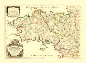
antique map reproduction bretagne

Map of the Brittany / Bretagne, 1706.

This map of Brittany shows the beginning of the 18th century when Brittany flourished as a strategic base for the French Navy and seaborne trade. The seaports of Saint-Malo, Lorient and Brest underwent a rapid development. At the time this map was released, the port of Saint-Malo was also an important hub for the French corsairs. One of the most famous corsairs was René Duguay-Trouin who was a native of Saint Malo. Duguay-Trouin led a very adventurous life, capturing hundreds of merchant ships and warships.

His adventures also included being imprisoned in Plymouth, Devon, and later capturing Rio de Janeiro. Benerson Little’s “The Sea Rover’s Practice: Pirate Tactics and Techniques, 1630–1730” is a must-read for everyone interested in 17th and 18th century pioneering and corsairing. Duguay-Trouin’s tactics are also described in this book.

Buy restored reproduction of this map printed on a high quality handmade paper here.
Algiers – the Hub of the Barbary Pirates

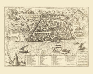
algiers antique map reproduction

Map of the City of Algiers, 1575.

Algiers was an important hub in 16th century North Africa. The part of the Ottoman Empire covering what is today Algeria, Tunisia and Libya was governed from Algiers. Piracy and raiding were popular activities of the Algerian rulers at this time and they organised numerous slave-hunting expeditions to the Western Mediterranean. Large populations were affected, namely on the islands of Gozo, Lipari, and Corsica. Several decades later, the coastal regions of Spain and Portugal also became a target of the Barbary pirates’ raids. These slave-hunting expeditions eventually reached as far as Iceland in 1627. The famous Spanish writer Miguel de Cervantes spent five years as a slave in Algiers. He was captured together with the rest of the galley crew while in their way from Naples to Barcelona.

The Barbary Pirates 15th–17th centuries” by pirate expert Angus Kunstam and illustrated by Gerry Embleton is a great introduction to the era of piracy in the 17th century Mediterranean.

Buy restored reproduction of this map printed on a high quality handmade paper here.
The Golden Age of Lisbon

vintage map reproduction lisboa

Map of the City of Lisbon, 1598.

The 16th century was the Golden era in Lisbon’s history. It was a starting point for many voyages of discovery and trade including those of Vasco de Gamma and Bartolomeu Dias. Their voyages and many that followed established many colonies and trading posts overseas. Circumnavigation of Africa opened up cheaper and faster transport of exotic goods from the Far East to Europe. Thus, Lisbon as a gateway to the newly discovered routes gained exclusive access to sources of products from the Indian subcontinent (spices, diamonds) and also from Africa (cotton fabrics, spices), Brazil (sugar), the Moluccas (spices) and China (porcelain, silk). The goods were further traded to the rest of Europe. This amount of trade made Lisbon one of the biggest, richest and most important cities in Europe and at that time, around 150 000 people lived in the city in late 16th century.

This era in Portuguese history is well documented in “Portuguese voyages 1498–1663 – tales from the Age of Discovery” by C.D. Ley (Editor).

Buy restored reproduction of this map printed on a high quality handmade paper here.

Riccioli – the Founder of Modern Lunar Nomenclature

vintage map poster moon

Map of the Moon’s Surface, 1742.

Published under the official title: Tabula Selenographica. Selenography is a scientific discipline focused on mapping the Moon’s surface. This early 18th-century map is derived from the works of two scientists who stood at the forefront of the modern-era survey of the Moon: the German-Polish astronomer Johannes Hevelius, a founder of modern day lunar topography, and Giovanni Battista Riccioli.

As religion and science were close disciplines in the 17th century, Riccioli was a Jesuit priest with a strong interest in astronomy. He received theological education and besides theology, he was later officially assigned to also focus his professional career on astronomy. He was based in Bologna where he founded an observatory and was the first scholar to describe the constant acceleration of falling bodies. Moreover, he created a system of lunar nomenclature that is still used today. The Sea of Tranquillity, the area where man first set foot on the Moon in 1969, was named by Riccioli.

Buy restored reproduction of this map printed on a high quality handmade paper here.

The Ferro Meridian

grrenland iceland antique map reproduction

Map of Greenland and Iceland, 1770.

Passages from east to west Greenland are charted. The Ferro Meridian which was used in the history as a Prime Meridian crosses Iceland. It was established based on the longitude of the island of El Hierro, the westernmost island of the Canary Islands. Already since the era of Ptolemy (2nd century A.D.) the Canary Islands were considered the westernmost land of the known World. The Greenwich Prime Meridian was established by English astronomer and mathematician Sir George Biddell Airy in 1851. The Prime Meridian used today is the International Reference Meridian which passes approx 102m of the Greenwich Royal Observatory.

Authobiography of Sir George Biddell Airy” includes birth story of the Greenwich Prime Meridian.

Buy restored reproduction of this map printed on a high quality handmade paper here.

Java under Dutch Control

java antique map reproduction

Map of the Island of Java, 1700

In 1700, Java was part of a Dutch colony that had been administered through the Dutch East India Company (VOC) for almost one hundred years. The VOC controlled much of the spice trade in the area of what is today Indonesia and beyond that. Batavia (today known as Jakarta) was established as the VOC headquarters in 1619. Based on agreements with the native kingdoms on Java, only Dutch ships were allowed to trade in the archipelago and so the VOC became the dominant ruler in the area. The Dutch sent close to a million people to Indonesia in the 17th and 18th centuries to further strengthen its control over the region.

Europe and a wider world, 1415–1715” by the British historian J. H. Parry comprehensively covers the Dutch colonial era in Indonesia.

Buy restored reproduction of this map printed on a high quality handmade paper here.

Handmade paper Lampshade

Map reproductions printed on a handmade paper are a classic, giving the maps the ancient look they need. I simply love this material and it is pleasure to test new ways of using it in home decor.

Here is my newest tip:

A Handmade Paper Lampshade

I collected and dried a few of meadow flowers last summer. I collected them on the fields around the house I grew up. When the flowers got dry I asked the paper maker who othwerwise makes handmade paper for my maps to insert the flowers into a Japanese style “washi” paper and make a few sheets of it for me.

Than I attached the paper on a lampshade construction made by my Dad, who is an electrician and attached the shade to a lampstand I purchased in IKEA. I called my new lamp “Hlavnov” after the hill I collected the flowers on. I have wonderful childhood memories from the place and my new lamp is their daily reminder:-)

I love the result! How do you like it?

handmade paper lampshade

1720s – High Baroque in Prague

prague antique map reproduction

Map of the City of Prague, 1720.

This map of Prague shows the three oldest quarters of the city: The Old Town (including the Jewish neighbourhood of Josefov), the New Town and the Lesser Town. In 1720, Bohemia with Prague as its capital was part of the Habsburg Monarchy ruled by Emperor Charles VI. The first half of the 18th century was a period of High Baroque architecture in Bohemia.
In the first half of the 18th century, Prague’s iconic Charles Bridge featured 30 baroque statues of saints.

Buy restored reproduction of this map printed on a high quality handmade paper here.

The First Circumnavigation of Australia

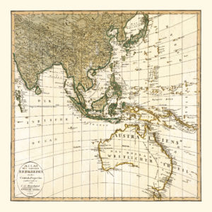
vintage map reproduction australia south east asiaMap of Southeast Asia and Australia, 1803.

This map depicts Southeast Asia and Australia as it was known to European mapmakers in 1803. There were several voyages aimed at exploring and mapping the continent; starting with Willem Janszoon who, as the first European, landed on Australia’s Cape York Peninsula in 1606, followed by Dirk Hartog’s navigation to the coast of what is today the North West Division of Western Australia in 1616 and Abel Tasman’s second voyage to map the continent’s northern coastline in 1644. The eastern coast was charted by Captain James Cook in 1770. The entire coastline had not been drawn into maps before the first voyage of Captain Matthew Flinders (1801-1802) during which he mapped the remaining part of the southern coast and proved that Van Diemen’s Land (Tasmania) was separated from Australia by a strait, named after Flinders’ fellow navigator George Bass. The strait is already depicted in this map. During his second voyage in 1803, Flinders circumnavigated Australia as the first European. After completing the circumnavigation, Flinders set off to sail back to England. However, he spent six years in French captivity after he stopped in Mauritius because of the poor condition of his vessel.

The life story of this famous navigator and cartographer is captured in Miriam Estensen’s “Mathew Flinders: The Life of Mathew Flinders“.

Buy restored reproduction of this map printed on a high quality handmade paper here.

The Spice Trade Booms in the 16th century’s Asia

asia antique map reproduction

Map of Asia, 1579.

A map of Asia by the famous Flemish cartographer Abraham Ortelius. The islands that are today part of Indonesia and the Philippines are shown on a larger scale compared to the size of the rest of the continent. This may be due to their relative importance for the spice trade that flourished in the 16th century. The Moluku islands became a special source for spice traders as cloves, mace, and nutmeg could originally only be found in the Moluccas. Long debates related to the position of the islands followed after the division of the World into the eastern Portuguese and western Spanish spheres as both superpowers attempted to keep the revenue from the spice trade.

This period of Maluku and European history is narrated by Charles Corn in his “The Scent of Eden: A History of the Spice Trade”.

Buy restored reproduction of this map printed on a high quality handmade paper here.