I am making lampshades again

To me, autumn is the most inspirational season. The light and the colours everywhere…

This year the autumn atmosphere made me come back to the beloved hobby I have: lampshade making.

Here are another two pieces I made, inspired by nature again.

Which one do you like more?

Colonization of Oceania

australia ocenani vintage map poster

Map of Australia and Oceania, ca 1876

British, Dutch, French, Spanish, Portuguese and American colonies are marked in the chart.

The second half of the 19th century was the pinnacle of the colonisation of Oceania. The process began in 1788 when Australia became a British colony. Smaller islands followed in the1840s: the French claimed the Society Islands, the Tuamotu Archipelago, the Gambier Islands and the Marquesas. Papeete, the largest settlement in Tahiti became the capital of French Polynesia. New Caledonia followed in the 1850s as a French penal colony. At first, the British were unwilling to claim larger areas of the Pacific due to the expensive administration of tiny, sporadically inhabited islands scattered across an enormous area. This changed with the opening of the Panama Canal in the 1880s, which opened up new nautical routes in the Pacific. The emergence of Germany and the USA as new colonial powers was another reason for the fast colonization of the Pacific islands in the late 18th century. The atmosphere of colonial Oceania is depicted in the memoirs of the famous British author Robert Louis Stevenson who travelled the Marquesas and the Gilbert Islands in the 1880s.

The Jacobite war in Ireland

ireland antique map poster

Map of Ireland (Hibernia in classical Latin) including its administrative division, 1688.

In 1688, Ireland was heading towards a civil war, often called the Williamite war or the Jacobite war in Ireland. The war was a result of the so-called Glorious Revolution in England when King James II attempted to re-establish the Catholic Church as the official religion in Britain. As a consequence, William of Orange invaded England to repress the king’s efforts. However, Jacobitism was widely supported in Catholic Ireland and the king, after being forced to flee England, used the emerald isle as a base to regain the English crown. In a three-year long conflict, various battles took place between the Jacobites and a multi-national army led by William of Orange. The conflict resulted in hundreds of thousands killed and others forced to flee abroad, which caused another large wave of exile from Ireland that continued throughout the next three centuries.

Robert Hooke’s Isle of Wight

antique map of the isle of wight


Antique map of the Isle of Wight and the adjoining area of what are today the counties of Dorset, Hampshire and West Sussex, 1693.

The Isle of Wight is the largest English island and is located a few kilometres off the coast of Hampshire. Many notable people have spent their time on the island. These include Queen Victoria and Prince Albert who built their summer residence there and the actor Jeremy Irons who was born there. Another famous resident of the island is the scientist, surveyor and architect Robert Hooke (1635–1703). It is difficult to pick out the most important achievement of Mr. Hooke. He greatly contributed to many scientific disciplines such as palaeontology, horology, astronomy, microscopy and physics. Hooke’s law still has its solid place within mechanics. He was also a notable surveyor and architect. During his studies at Oxford, he became the life-long friend of Sir Christopher Wren and became his chief assistant after the Great Fire of London in 1666. Among other achievements, he participated in the design of some of London’s icons, such as the Royal Greenwich Observatory and St. Paul’s Cathedral. Without a doubt, he was a maverick and engaged in many disputes with other scientists, including a well-known dispute with Sir Isaac Newton, on their achievements in the field of gravitation. As a native of the Isle of Wight, he is one of the most important figures in the island’s history. The Robert Hooke Society has been established to raise awareness and appreciation of the life and achievements of this great scientist. Lisa Jardine’s “The Curious Life of Robert Hooke: The Man Who Measured London” provides a fascinating biography of this notable man.


Titian’s Italy

italy antique map - mappa antica italia


Old map of Italy and Corsica, 1570.

Italy underwent a rapid cultural development in the 16th century. This period is often called Cinquecento – a term that sums up all the cultural events in Italy between 1501 and 1600. Renaissance was in its high period and its characteristics were continuously adopted by courts across Europe. In the early 16th century, some of the most famous painters of all time such as Leonardo da Vinci (1452–1519) and his contemporaries Michelangelo (1475­–1564), Raphael (1483–1520) and Titian (1488–1576) created their fine works in Italy. The youngest of the group, Titian, was based in Venice and qualified as one of the most respected painters of his era. In 1570, when this map was first printed, Titian worked as a court artist for King Phillip II. He painted a series of large mythological paintings for him, as well as many works inspired by Christianity and numerous portraits. He was hailed as “The Sun Amidst Small Stars” by his contemporaries. (The sentence itself is a reference to the final line of Dante’s Paradiso.) Sheila Hale’s “Titian: His Life” sums up the life and achievements of this artist in the era of High Renaissance.

The trade in the Gulf of Guinea

gulf of guinea vintage map

The first European bases were established in the Gulf of Guinea in the 15th century; first by the Portuguese, followed by the Dutch, the British and the French. These served as hubs for trading goods and supplying stations for convoys of ships voyaging further south. In addition to the goods, the slave trade began almost immediately after the Portuguese arrived who took captives to use as slaves back in Portugal. After Columbus voyaged to America and new colonies in the West were established, the demand for labour had risen rapidly, and the Atlantic slave trade began on a large scale. The trade was legalised by the Spanish and the English Crowns.

The Atlantic slave trade reached its peak during the 17th century. It is highly likely that many of the captives were taken during wars between the local rulers who were trying to meet the demand for slaves. The slave trade is also one of the possible reasons why the Songhai Empire (an important large Empire in the Gulf of Guinea Region) split into several smaller states.

Gold, spices and ivory were the main items traded between Africa and the rest of the world. Some parts of the Gulf’s coastline were later named after these: Slave Coast (present-day Benin), Gold Coast (present-day Ghana), Ivory Coast (Cote d’ Ivoire) and Pepper Coast (present-day Liberia).


Mediterranean Sea – the 17th century battlefield

mediterranean sea old map poster

Map of the Mediterranean Sea and the adjoining areas in the second half of the 17th century.

The dominant power in the Mediterranean Region in the second half of the 17th century was the Ottoman Empire. By then, it had controlled almost the whole coastline of the Balkan Peninsula (together with the Republic of Radusa, its vassal state), the whole of Asia Minor and a major part of the North-African coast, from today’s Algeria eastwards. Cyprus was also seized and Crete was actually being conquered at the time this map was printed. The remaining western parts of the coastline were controlled by Spain, France, the Republic of Venice, the Kingdom of Sicily and several other states in the area of today’s Italy. These were all natural rivals of the Ottoman Empire. Numerous battles raged between the Turks (and the Barbary Pirates) and their European rivals in the Mediterranean Sea in the second half of the 17th century. In 1665, one such battle took place near the coast of Tunisia. The Barbary pirates’ fleet was defeated in this battle by the French nobleman Duc de Beaufort and his ships. Duc de Beaufort is a fascinating figure from French history. As a grandson of the French King Henry IV, he served in the army during the Thirty Years’ War and took part in an unsuccessful plot against Cardinal Richelieu, which resulted in his exile in England. Upon his return to France, he was imprisoned for engaging in another conspiracy. He later escaped from prison and was appointed as the chief of the French Navy’. In addition to the victory over the Barbary Pirates in 1665, he waged various other battles in the Mediterranean Sea in the 1660s. He was killed during the Siege of Candia in 1669.

Andalusia blossoms as the Atlantic trade increases in the 17th century

andalusia vintage map poster

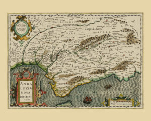
Map of the Spanish region of Andalusia in the early 17th century.

At the beginning of 17th century, Spain underwent rapid development and Andalusia was no exception. On the contrary, it was one of the most influential and prosperous regions under the Spanish Crown. Given its strategic position, the cities of Seville and Cadiz were gateways for all goods imported to Europe from the Spanish colonies. This was Palos de la Frontera, a port on the Atlantic coast of Andalusia, and from where Christopher Columbus departed from on his voyage in 1492. Many Andalusians participated in his expeditions and later became responsible for organising shipping lines between Spain and the colonies. Following the fall of Grenada in the same year, Muslim rule on the peninsula ended and Islam was pronounced an illegal religion in Spain. In the years to come, the Moorish population was forced to convert to Christianity and scattered throughout the other parts of Spain.

At the time this map was printed, i.e. about one hundred years after Columbus’ expedition, the trade between The New World and Spain was booming, and Andalusia took a large share of the profit. The economic boom was a breeding ground for the Spanish Golden Age, an era in Spanish history where major works of art in painting, music, and literature were created. This era is represented by the famous painter Diego Velasquez, an Andalusian native, and Miguel Cervantes Saavedra, who spent several years of his life in Seville.

Jean Canavaggio’s biography “Cervantes” presents the Golden Spanish Age through the life and work of this famous Spanish author.

Oceania after James Cook voyages

old map of the pacific ocean, Oceania

Map of the Pacific Ocean, 1803

North-West of America is also included. This chart is part of a set of six square maps of the world.

The Pacific islands had been a target of exploratory voyages by the Europeans from the 16th century onwards. The Portuguese and Spanish came first in search of new sources for spices and other exotic goods followed by the Dutch and their VOC fleet. However, it was the voyages of Captain James Cook in the second half of the 18th century that changed Oceania for good. His three voyages significantly contributed to the exploration and mapping of the area and prepared the ground for the colonisation of the Pacific islands from the 1830s onwards. James Cook was killed in Hawaii during his third voyage in 1779, just 24 years before this map was printed. Hawaii is named as the Sandwich Islands on this map, which was the name given to the archipelago by Cook himself during his third voyage.

Toledo: El Greco’s new home

old map of spanish regions, cadiz, carpetania, cantabria

Three Antique Maps of Carpetania, Cantabria and the Bay of Cadiz, 1584

This is a set of three maps showing three regions of Spain: Cadiz Bay, an important harbour in the 16th century, a region covering the eastern coast of the Bay of Biscay in the far north of Spain and the ancient region of Carpetania (an area approximately south of Madrid, in the middle of the Taugus river basin). The city of Toledo is also included in the bottom-left corner of the Carpetania map. At the time this map was first printed, Toledo was home to the famous Greek painter, sculptor and architect Domenikos Theotokopoulos, known in the art world as El Greco. Originally from Crete (part of the Venetian Republic at that time), he had lived in Rome and Venice before settling down in Toledo, where he spent half of his life and created most of his fine art works. “El Greco” by D. Davies, J.H. Elliott, X. Bray and K. Christiansen is a fantastic introduction into both his artwork and his personal life.