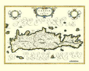
Map of the Island of Crete (Candia), 1644.
This map shows the island of Crete during a particularly turbulent time. In 1644, it was still a Venetian colony and its official name was The Kingdom of Candia. After the Republic of Venice lost Cyprus in the 1570s, the Kingdom of Candia remained its last major overseas dominion. The Ottomans were set on the island due to its strategic position in the Mediterranean Sea. That year, Maltese ships attacked an Ottoman convoy that was heading from Constantinople to Alexandria. The convoy carried a number of pilgrims bound for Mecca including a woman who was believed to be one of the wives of the sultan and her son. The Maltese won the battle and took captives to be sold as slaves.
On the voyage home, the Maltese stopped in Crete to take on supplies. The Ottomans considered this act a breach of Venetian neutrality and declared war on the Republic of Venetia. Most of the island was conquered by the Ottomans in the early years of the war. The capital city of Candia (now Heraklion) resisted until 1669, thus making it one of the longest sieges in history.
Buy restored reproduction of this map printed on a high quality handmade paper here.
