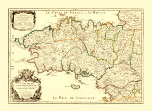
Map of the Brittany / Bretagne, 1706.
This map of Brittany shows the beginning of the 18th century when Brittany flourished as a strategic base for the French Navy and seaborne trade. The seaports of Saint-Malo, Lorient and Brest underwent a rapid development. At the time this map was released, the port of Saint-Malo was also an important hub for the French corsairs. One of the most famous corsairs was René Duguay-Trouin who was a native of Saint Malo. Duguay-Trouin led a very adventurous life, capturing hundreds of merchant ships and warships.
His adventures also included being imprisoned in Plymouth, Devon, and later capturing Rio de Janeiro. Benerson Little’s “The Sea Rover’s Practice: Pirate Tactics and Techniques, 1630–1730” is a must-read for everyone interested in 17th and 18th century pioneering and corsairing. Duguay-Trouin’s tactics are also described in this book.
Buy restored reproduction of this map printed on a high quality handmade paper here.
