Tag Archives: 16th century

The End of the Inca Empire

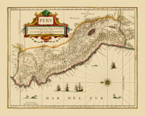
old map reproduction peru

Map of the Viceroyalty of Peru (an administrative unit of the Spanish Colonial Empire at that time), 1600.

By 1600, the last Inca Emperor had died and the Inca Empire had been under Spanish rule for over two decades. The Viceroyalty of Peru was established by the Spanish, which also included the areas of what is today Ecuador and Bolivia. Spanish supremacy was a major step towards the downfall of Inca civilisation. Many aspects of Inca culture were systematically destroyed by Spanish colonial officials. Several waves of epidemic diseases brought over from Europe by the occupiers were, even more, destructive: smallpox, measles, influenza and typhus ravaged the majority of the Inca population. To learn more about the Spanish conquest of what is now Peru, read “The Conquest of the Incas” by John Hemming or “In Search of an Inca: Identity and Utopia in the Andes” by the Peruvian author Alberto Flores Galindo.

Buy restored reproduction of this map printed on a high quality handmade paper here.
Algiers – the Hub of the Barbary Pirates

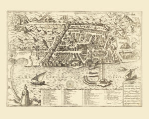
algiers antique map reproduction

Map of the City of Algiers, 1575.

Algiers was an important hub in 16th century North Africa. The part of the Ottoman Empire covering what is today Algeria, Tunisia and Libya was governed from Algiers. Piracy and raiding were popular activities of the Algerian rulers at this time and they organised numerous slave-hunting expeditions to the Western Mediterranean. Large populations were affected, namely on the islands of Gozo, Lipari, and Corsica. Several decades later, the coastal regions of Spain and Portugal also became a target of the Barbary pirates’ raids. These slave-hunting expeditions eventually reached as far as Iceland in 1627. The famous Spanish writer Miguel de Cervantes spent five years as a slave in Algiers. He was captured together with the rest of the galley crew while in their way from Naples to Barcelona.

The Barbary Pirates 15th–17th centuries” by pirate expert Angus Kunstam and illustrated by Gerry Embleton is a great introduction to the era of piracy in the 17th century Mediterranean.

Buy restored reproduction of this map printed on a high quality handmade paper here.
The Golden Age of Lisbon

vintage map reproduction lisboa

Map of the City of Lisbon, 1598.

The 16th century was the Golden era in Lisbon’s history. It was a starting point for many voyages of discovery and trade including those of Vasco de Gamma and Bartolomeu Dias. Their voyages and many that followed established many colonies and trading posts overseas. Circumnavigation of Africa opened up cheaper and faster transport of exotic goods from the Far East to Europe. Thus, Lisbon as a gateway to the newly discovered routes gained exclusive access to sources of products from the Indian subcontinent (spices, diamonds) and also from Africa (cotton fabrics, spices), Brazil (sugar), the Moluccas (spices) and China (porcelain, silk). The goods were further traded to the rest of Europe. This amount of trade made Lisbon one of the biggest, richest and most important cities in Europe and at that time, around 150 000 people lived in the city in late 16th century.

This era in Portuguese history is well documented in “Portuguese voyages 1498–1663 – tales from the Age of Discovery” by C.D. Ley (Editor).

Buy restored reproduction of this map printed on a high quality handmade paper here.

The Spice Trade Booms in the 16th century’s Asia

asia antique map reproduction

Map of Asia, 1579.

A map of Asia by the famous Flemish cartographer Abraham Ortelius. The islands that are today part of Indonesia and the Philippines are shown on a larger scale compared to the size of the rest of the continent. This may be due to their relative importance for the spice trade that flourished in the 16th century. The Moluku islands became a special source for spice traders as cloves, mace, and nutmeg could originally only be found in the Moluccas. Long debates related to the position of the islands followed after the division of the World into the eastern Portuguese and western Spanish spheres as both superpowers attempted to keep the revenue from the spice trade.

This period of Maluku and European history is narrated by Charles Corn in his “The Scent of Eden: A History of the Spice Trade”.

Buy restored reproduction of this map printed on a high quality handmade paper here.

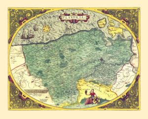
Flanders in 1570s – Rebellion against the Spanish Rule

flanders vintage map poster

Map of Flanders, 1573.

This map of Flanders is a reproduction of the original map of Flanders by Gerhard Mercator, one of the founders of modern cartography. It was later copied by his disciple, another famous Flemish cartographer by the name of Abraham Ortelius and was reprinted in several editions – this being one of them.

In the 16th century, Flanders covered the western part of what is today Belgian Flanders (the River Scheldt being the frontier on the East), the western part of what is today Belgian Wallonia, as well as small areas that are today the Netherlands (the southern part of the Zeeland province), and France (Lille region).

In the second half of the 16th century, the Low Countries were undergoing turbulent times. Protestantism was becoming increasingly popular in the region, which was frowned on by the Spanish Hapsburgs, who ruled the area at that time. In 1568, Seven Northern Provinces led by William Orange revolted against the Hapsburgs and the rebellion quickly spread throughout the region. The Low Countries were of strategic importance to the Spanish Crown – Antwerp, Bruges, and other coastal towns were crucial gateways for Spanish colonial goods to Europe. In 1581, the Seven Northern Provinces declared their independence, although the uprising in the Southern Provinces was repressed in 1585 when Antwerp fell after twelve months of siege.

Helena Soister’s book “Prophecies” is historical fiction set in 16th century Antwerp.

Buy restored reproduction of this map printed on a high quality handmade paper here.